Soper Creek Subwatershed Study
More
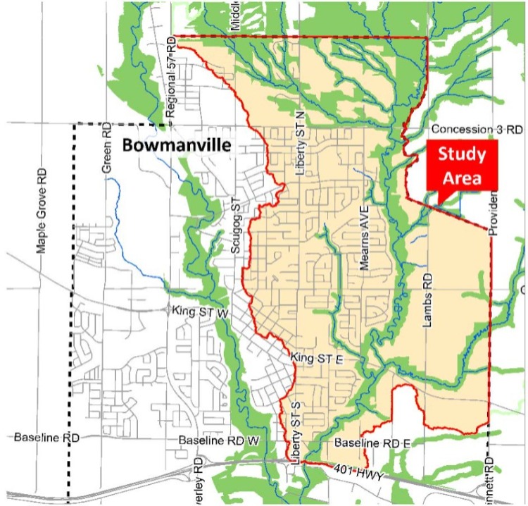
![]()

Public Information Centre (PIC) #2
Join us at our second PIC on Thursday, April 10, 2025, beginning at 6:30 p.m. to learn about the Soper Creek Subwatershed Study Phase 2 and 3 report. The presentation will summarize the findings in the report, outline the environmental management strategy and share recommendations for future land development in this area.
Date: Thursday, April 10, 2025
Time: Presentation begins at 6:30 p.m.
Location: Garnet B. Rickard Recreation Complex (Hall 2) - 2440 Highway 2, Bowmanville
View the public meeting notice.

The Soper Creek originates on the Oak Ridges Moraine and has a drainage area of approximately 7,730 hectares (77 square kilometres). The Soper Creek flows southeast across the northern part of Bowmanville and continues southerly along the eastern limits of the Bowmanville Urban Area.
There are four subwatersheds within the Soper Creek drainage basin: Mackie, Soper North, Soper East and Soper Main. This subwatershed study will focus on the areas of the Soper Creek Subwatershed that are located within the Bowmanville Urban Area.
The Subwatershed Study will balance the natural and human environments in areas that are anticipated to experience urban development. These recommendations will guide sustainable development of land.
The Phase 2 and 3 report provides a strategy and recommendations for protecting and enhancing environmental features in the subwatershed area. These recommendations and strategies, which include vegetative buffers, low-impact development techniques, and stormwater management controls, will inform the drafting of the Soper Hills and Soper Springs Secondary Plans, as well as future development patterns in these areas.
The foundation of these recommendations was the Phase 1 Existing Conditions report, which was completed in December 2022. It characterized groundwater, surface water and ecological resources as well as flooding and erosion, the natural heritage system and headwater drainage features within the study area.
Read the Soper Creek Subwatershed Study Report
|
Phase 1 study report |
|
Phase 1 of the Study investigated and inventoried the natural resources which could be impacted by future urban development within the Study area (shown on the map above). This creates a base of information that will be used to develop stormwater management and natural heritage strategies in the next phase of the Study to protect, rehabilitate, and enhance the environment within the Study area limits. The Phase 1 (Existing Conditions) Report provides information on groundwater, surface water and ecological resources within the study area, as well as flooding and erosion constraints, the natural heritage system, headwater drainage features and recommendations for further study.
Presentation of key findings from the Phase 1 (Existing Conditions) Report were presented at Public Information Centre #1 (see below). |
| Public Information Centre #1 – December 6, 2022 |
Over 30 people attended the first Public Information Centre for the Soper Creek Subwatershed Study. Staff and the Municipality’s consulting team, Aquafor Beech Limited and SGL Planning and Design Inc., were on hand to answer questions. Information about existing conditions in the study area, including groundwater, biodiversity, streams, and erosion and natural hazards was presented.
|
Contact Us


