Public Meeting Notice: Have your say on two planned community areas in Courtice and Bowmanville
More
![]()
Clarington is committed to responsible growth through careful planning of complete, sustainable and vibrant communities.
On May 12, 2025, Clarington will present two draft Secondary Plans and their associated Official Plan Amendments – and we want to hear from you!
What is a Secondary Plan? A Secondary Plan is a detailed set of rules and guidelines for developing a specific area within Clarington. It helps determine things like where buildings can go, how tall they can be, what kinds of businesses can operate there, and what kind of roads, parks, amenities and greenspace are needed. Secondary Plans are important because they help make sure the area develops in a way that meets the community’s needs and fits with the rest of the municipality.
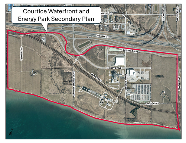
The refreshed vision for the Courtice Waterfront and Energy Park Secondary Plan includes the creation of a new waterfront community featuring a prestigious municipal-wide park. This new Waterfront Park will significantly increase access to Lake Ontario and attract residents from across Clarington and beyond with year-round recreational opportunities.
The plan also protects land for employment uses and supports the development of a mixed-use neighbourhood with a variety of housing and commercial amenities—such as shopping, dining, and services—all while being surrounded by greenspace.
The Courtice Waterfront and Energy Park Secondary Plan is located south of Highway 401, east of Darlington Provincial Park, north of Lake Ontario, and west of Crago Road.
Learn more at www.clarington.net/CourticeWaterfront.
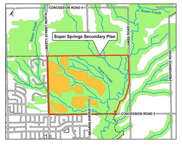
The vision for the Soper Springs Secondary Plan includes creating a compact, complete, connected and walkable community, leading to a sustainable built form (how a community looks and feels) that protects the significant natural environment, promotes alternative modes of transportation, and supports a healthy lifestyle for current and future generations.
The plan also supports the development of a mixed-use neighbourhood with a variety of housing types and services, along with integrated connections to nature, parks and trails -- all while being surrounded by green space.
The Soper Springs Secondary Plan area is located on the north side of Bowmanville. It is generally bound by Liberty Street North to the west, Concession Road 3 to the south, and Lambs Road to the east. The northern boundary runs aligning with the Bowmanville urban boundary.
Learn more at www.clarington.net/SoperSprings.
Review the draft Secondary Plans and join us at Council Chambers, Municipal Administrative Centre, 40 Temperance Street, Bowmanville or attend virtually by watching the live stream at www.clarington.net/calendar.
Date: Monday, May 12, 2025
Time: Meeting begins at 6:30 pm (please note there are two items on the Public Meeting agenda)
Place: Online or in person in Council Chambers, Municipal Administrative Centre, 40 Temperance Street, Bowmanville
If you are attending online and wish to speak at the public meeting, please pre-register by completing the online form at www.clarington.net/delegations or contact the Clerk’s Division at 905-623-3379 ext. 2109 or clerks@clarington.net by Friday, May 9, at 3:30 p.m. Once registered, staff will provide further instructions. If you are attending in person, you do not need to pre-register as a delegate to speak at the meeting.
For additional information on how to provide comments, join the interested parties list and more, please visit the project webpages at:
Contact Us


